Historic Engravings from near Nortonville and
Black Diamond Landing, California
Index to Engravings on this Page:
• 1870 Engraving from the hills above Notonville, CA looking toward Black Diamond Landing, CA
• 1869 Engraving of Black Diamond Landing, CA
1870 Engraving from the hills above Notonville, CA looking toward
Clayton, CA:

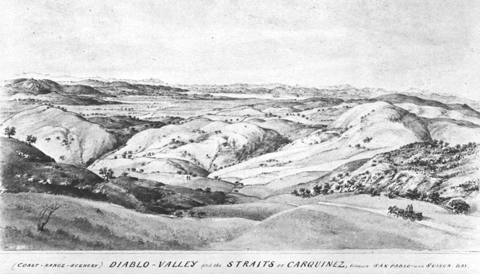
NO. 27. DIABLO VALLEY AND STRAITS OF CARQUINEZ.
From "Vischer's Pictorial California," published April 1870.
The following is the original text that accompanied the engraving:
This view (in a northerly direction) is taken from an elevation of about
1,700 feet above the level of the sea, a peak in the northern declivities
of Mount Diablo Range, about two and one-half miles from the town of
Clayton, the site of which is indicated by the shaded portion of the
rolling calcareous ridges occupying the middle ground of our picture.
Clayton, the largest town created by the coal mining interest, stands at
the head of Diablo Valley at the foot of Mount Zion, on a plateau studded
with oak groves; and although only founded since 1862, is closely
settled and surrounded by fine orchards, vineyards and gardens, the
largest vineyard of 30,000 vines being that of Mr. Clayton, an enterprising
citizen after whom the town is named. But the chief element
of this place is the vicinity of the coal mines.
The Mount Diablo coal range commences about two miles south from
Clayton, and its northern extremity, well defined by the characteristic
stratification of its layers, occupies the right side of our foreground,
just beyond the small ravine opposite the wagon returning from the
Coal District, in the direction towards Clayton — while the left corner is
occupied by the declivities of the hill, which we have chosen for our
stand point, bearing the stunted growth of scrub oak peculiar to this
region, m o r e visible at the border of the ravine.
The chief interest of this sketch lies in the opening of Diablo Valley,
with Clayton, on a plateau, at its head; Pacheco at the foot of the descending
ridges to the left, and Martinez (the county seat of Contra
Costa) close to the Bay.
The portion of the Bay here visible are the Straits of Carquinez, between
San Pablo and Suisun Bay. showing Martinez on the near, and
Benicia with its shipyard on the opposite shore, with the mountain
ranges north of the Bay of San Francisco rising in amphitheatre, and
showing several culminating peaks of which Mount St. Helena, in the
far distance, is the most prominent.
This landscape, though unaided by striking outlines or any forcible
effects, is a highly graphic exponent of the characteristics of Mount
Diablo scenery; the grand feature of which, Mount Diablo range, is the
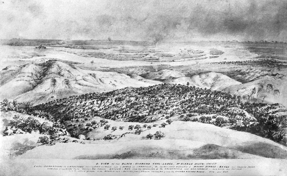
subject of our next number, while a third view, reserved for another
portion of our work (see addition from the material of the Review of
California's Progress,) represents the western declivities, Suisun Bay, the
Diamond coal ledge with the semi-circle of chalky mounds, the confluence
of the Sacramento and San Joaquin and the corresponding plains,
with a distant glimpse of the Sierra Nevada.
"[This engraving] represents the western declivities, Suisun Bay, the
[Black] Diamond coal ledge with the semi-circle of chalky mounds, the confluence
of the Sacramento and San Joaquin [Rivers] and the corresponding plains,
with a distant glimpse of the Sierra Nevada." (Text in brackets denotes deviations from the original.)
1870 Engraving from the hills above Notonville, CA looking toward Black Diamond Landing, CA:

S. VIEW OF THE BLACK – DIAMOND COAL – LEDGE, MT. DIABLO DISTR: Co. Co. Cty.
From "Supplement to Vischer's Pictorial," circa 1870
![]()
1869 Engraving of Black Diamond Landing, CA:

VIEW OF BLACK DIAMOND LANDING, CALIFORNIA, CIRCA 1869
From the Southport Land and Commercial Company Archives.

